Relics, found and otherwise (Part 1)On NW First Avenue, between Couch and Davis near the old Import Plaza Building sits a shin level mystery.  It is too low to work as a bench, too high to be part of the planter that borders it. The inscription: GRAND-CENTRAL, suggests a railroad station.
This in a way is correct. The New Grand Central was a hotel that once towered over Third and Flanders, near Union Station. The sandstone piece is one of a surprising number of Portland relics hidden in plain sight.
 Click on pictures to expand. Photo courtesy of the Architectural Heritage Center.When completed in 1892 by beer mogul Henry Weinhard, the New Grand Central Hotel, on the corner of 3rd and F street, was ideally situated for arrivals from Portland's still under construction Grand Central Passenger Station (Union Station was more a descriptive term than a proper name at the time) and the steamship docks on the Willamette River. The area was a gateway to Portland for travelers, where City and Suburban Railway streetcars descended from the original Steel Bridge into the evolving hotel district to continue downtown on Third Street.
 The five story building was designed by architect Henry Hefty (see Peripheral Explorations) in the prevailing Romanesque revival style. It featured a decorative tower and all the modern accouterments of the day."The New Grand Central contains 142 handsomely furnished rooms, a well furnished office, an attractive dinning room, bar and barber shop, electric lights and elevator. Artesian water and steam heat are supplied throughout the house."-The Oregonian's Handbook of the Pacific Northwest, published in 1894.
 Looking east on Flanders, towards the new Steel Bridge, post-1915 with an arch from "The Great Light Way" over the intersection at Third. The Royal Palm Hotel in the foreground still exists.
Nearly a quarter century later, by 1915, Portland's luxury hotels were concentrated downtown, while hotels near Union Station, such as the New Grand Central, Hoyt, Royal Palm, Del-Mae-Joe and the Golden West (the only hotel in Portland open to African Americans) catered to travelers of more modest means.Downtown was moving west, away from its 1890s center on Third Street. In response, the street's merchants banded together to create "The Great Light Way" of lit arches on Third from Glisan to Yamhill, to provide an attraction to arrest downtown's drift.North of Burnside, Portland's Japantown, or Nihonmachi, had coalesced between NW Second and Fifth streets. Japanese American businessman T. Yuasa leased the New Grand Central from the Weinhard estate, renovated it and renamed it the American Hotel.
Hotel operation was an attractive business for Japanese immigrants as it provided both a livelihood and a place for their families 30 Japanese American hostelries north of Burnside. "Building leased for a term of years by T. Yuasa: Since the installation of the arches at the intersection of the streets on Third Street, a rejuvenation of this thoroughfare is indicated by the lease of the five story building. ...It has heretofore been known as the New Grand Central Hotel. The building was constructed in 1892 and is one of the landmarks of that section of Portland. It is held that this marks the beginning of a new era for this particular section of Third." -The Oregonian, June 1915. Japanese born immigrants (Issei) were barred from owning real estate. To operate a hotel, they either had to purchase it in the name of one of the U.S. born children, or lease, as T. Yuasa did. Although the opening of Yuasa's establishment was written up by the Oregonian as evidence of revitalization along "The Great Light Way," the public face of the hotel was that of clerk W.H. O'Donald in this advertisement from the Portland City Directory of 1915.
 .jpg) A 1948 view looking north on Third with a flood detoured Mt. Tabor streetcar and the American Hotel. The wooden building is shown in the 1889 Sanborn Insurance atlas as the St. Lawrence Hotel. Photo courtesy of Sheldon Perry.The American Hotel's proprietors changed frequently throughout the 1920, before settling on Joseph Grimm, who operated it from 1935 to 1950. During World War II, the neighboring Royal Palm Hotel was opened to African American shipyard workers as wartime housing. It is not known if the American Hotel was utilized likewise.
A 1948 view looking north on Third with a flood detoured Mt. Tabor streetcar and the American Hotel. The wooden building is shown in the 1889 Sanborn Insurance atlas as the St. Lawrence Hotel. Photo courtesy of Sheldon Perry.The American Hotel's proprietors changed frequently throughout the 1920, before settling on Joseph Grimm, who operated it from 1935 to 1950. During World War II, the neighboring Royal Palm Hotel was opened to African American shipyard workers as wartime housing. It is not known if the American Hotel was utilized likewise.
 By the time this photograph was taken in the early 1970s, the building's tower had long been removed. -Courtesy of the Architectural Heritage Center.
In 1950 the building was sold to the Union Gospel Mission who operated it as their Friendly Home until 1973. It then sat largely vacant until being demolished in 1978.
 Undated newspaper clipping from the Multnomah County Library's collection, circa mid 1970s.The story would usually end there. Another part of old Portland, gone, without a trace.However, three decorative fixtures, including the Grand Central sandstone block survived, along with a small segment of wall that bordered the parking lot that replaced the building. The pieces were acquired by the Portland Friends of Cast-Iron group, who were repatriating cast-iron remnants throughout the Skidmore Oldtown and Yamhill Historic Districts. They came to the attention of Bill Naito who was pursuing his vision of a revitalized Old town that built upon the areas history.
Bill Naito obtained the three fragments for use as decorative elements in the neighborhood. The Grand Central sandstone blocks he placed on the lot of his Import Plaza store, at the north east corner of First and Couch.


It is not known if Bill Naito's interest in the pieces was just for their age, or if he knew of the old hotel's association with Portland's Japantown. A comparison of the Grand Central blocks with his sign on the Import Plaza building suggests that it might have had some extra meaning for him.


The other two pieces from the New Grand Central were placed in a nearby alley of Couch, between First and Second, where they can be accessed through Floyd's Coffee Shop.
The remaining wall segment of the old hotel was finally demolished in the late 1990s for the construction of the Classical Chinese (now Lan Su) Garden.
(Part 2 of Relics, found and otherwise to follow).
Thanks to Portland's own Architectural Heritage Center for use of the color photographs of the New Grand Central building, Brandon Spencer-Hartle for
pointing out the sandstone blocks to me, and Bill Hawkins for telling me how they got there.

Updates, Log jams, Good and Bad News...
First the bad news. The theme of this article is relics that are hidden in plain sight (and some, surprisingly absent). Sadly the New Grand Central sandstone blocks were not hidden enough. During the time spent researching this post it was vandalized - pushed over, and now is in three, instead of two pieces. The damage is largely to hits patina, nothing another ten years of moss will not cure. The break is clean and seamless. The fact that it is face down probably protects it from further attention. It needs help and protection. Perhaps a better spot for it is in the safely locked courtyard / alley that holds its former companions.
I am happy to be a clearinghouse for information, ideas and concerns regarding efforts to restore and protect the pieces. My email address is my first initial, d followed by my last name (see profile) @comcast.net.
This post was too long coming. It kept growing, both the main article and smaller related pieces. I decided the best thing to do was to break it up. Part 2 will follow but I can not guarantee it will be the next one, as other posts line up at the gate. I think a course change is in order, with smaller, more frequent posts to gain prominence. Watch this space.
The good news: It looks like the David Campbell Memorial (previous post) is safe, at least from being parted out. It to has been recently vandalized (tagged) but has been repaired.
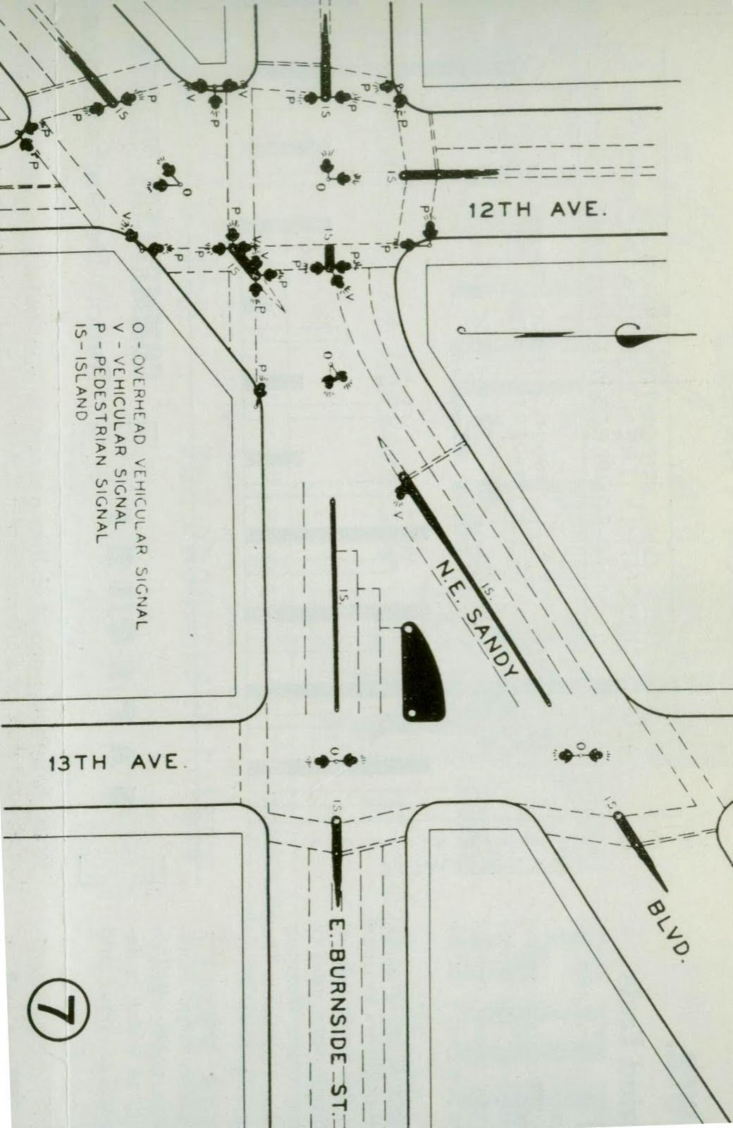
 Finally, recently I showed up on KATU Channel 2 news to talk about the late "intersection from hell" at Sandy, Burnside and 12th. KATU has an article and clip here.
Two Fountains It is our lot, those of us who care about conserving Portland's treasures, to play defense.
 The Shemanski Fountain, built in 1926, a gift from Joseph Shemanski, a Polish immigrant, to the city that showed him kindness.
On the night of April 25 2007 vandals attempted to steal the statue, Rebecca at the Well, within the Shemanski Fountain in the Park Blocks. The statue's base held, but the fountain was heavily damaged. Months of restoration work followed. Since being repaired the fountain was damaged again, this time by metal thieves looking to cash in from selling its fixtures. Today it bears the marks of recent tagging. The incidents highlight the disturbing vulnerability of our public heritage resources to those tone-deaf to anything but their own impulses. Possible solutions, barriers or relocation are unacceptable; to protect Portland's communal historic places from vandals and thieves can present challenges to their very nature as shared space.
To protect them from Portland's government might be harder still. At the intersection of SW 18th and Burnside in Portland Firefighter's Park is another fountain, the David Campbell Memorial, which faces threats even more immediate and dire than those pitted against the Shemanski Fountain.
  The Union Oil fire, June 26 1911. -From Portland Fire and Rescue by Brian K. Johnson and Don Porth, Arcadia Publishing.On June 26, 1911, Portland's Fire Chief, David Campbell was directing the response to a massive fire at the Union Oil Company on the southeast corner of Water and Salmon in south east Portland. The fire, fed by abundant fuel, was so large that it attracted crowds to the area estimated by the Oregonian at ten thousand. As the structure weakened, retreat was called. David Campbell entered the building to make sure there were no longer firefighters within. A huge explosion brought the wall down that killed him.
 The corner of SE Water and Salmon, January 2010, home of Pratt and Larson's tiles seconds room. The building was constructed nine years after the Union Oil fire.Portland's fire chief for eighteen years, David Campbell was a beloved local figure whose firefighting career spanned back to the days of the volunteer fire department prior to 1883. As chief, he was an innovator who introduced motorized vehicles and fire boats to the department. His funeral procession, witnessed by 150,000 people, was likely the city's largest outpouring of public grief."I loved Chief Campbell and I want everyone to know how good he was. He always had a smile and a kind word for all the school children. Whenever we were late he used to take us up to school in his auto just a-whizzing, and at noon we used to hurry back from lunch and he would let us ride with him. I think he was the best fire chief that ever lived. I want to be good to the children when I get big, like he was."
-Maurice Johnson, ten years old from the Rose City Park neighborhood, in the Oregonian, June 27 1911 (from a hand written note that he delivered to the Oregonian office). Portland Fire Chief David Campbell.
-From Portland Fire and Rescue by Brian K. Johnson and Don Porth, Arcadia Publishing.The David Campbell Memorial and Medal Fund was established on June 21 1913 to commemorate David Campbell and all Portland Firefighters who lost their lives in the line of duty to follow. Land at 18th and Burnside was donated to the city by Katherine A. Daley in 1918.
The memorial was designed by architect Paul Cret of Philadelphia, whose career would include the Folger Shakespeare Library in Washington DC, the Main Building of the University of Texas at Austin and the Cincinnati Union Terminal. Constructed from Caen limestone imported from France, it was dedicated by Mayor George Baker on June 27 1928.The grounds bordering the memorial were expanded to create Portland Firefighter's Park in 1964, which includes a list of thirty two Portland firefighters that lost their lives in the line of duty and an alarm bell dating from the year after the great Portland fire of 1873. Below; drawings by Paul Cret for the David Campbell Memorial from Philadelphia Architects and Buildings:
 January 2010.
 January 2010.A proposal for a new fire fighters memorial to be built near the east side of the Hawthorne Bridge has been announced, supported by Commissioner Randy Leonard. Three finalists are being considered with hopes of a dedication on June 26 2011, the hundred year anniversary of David Campbell's death. The goal of the David Campbell Memorial Association is to provide a larger more accessible memorial to Portland's fallen firefighters.
It would be hard to harbor reservations against the well intentioned project were it not for the fact that it entails the destruction of the original memorial. Plans include the removal of the bronze plaque and at least one lantern to incorporate them into the new structure. To cannibalize a historic civic space to build a new memorial shows an almost inconceivable degree of disregard for Portland's shared heritage. Commissioner Randy Leonard in the January 21 2010 Oregonian provided justification stating:
"It's a memorial, unfortunately that time will disintegrate."
Which is true - in so much as the same thing could be said about nearly everything.
The sentiment is echoed on the Portland Firefighters Memorial website:
"Sadly, the 81 year old memorial is crumbling and beyond repair, experts predict that it will not withstand many more winters."
Which stretches the definition of beyond repair well past the breaking point. "...crumbling and beyond repair..."Despite a very limited public process, word of the plan to demolish the original memorial is spreading and efforts to preserve it are starting to coalesce. A facebook page, a petition, testimony at city hall and numerous articles seek a larger airing of the issue.
The question is not if Portland's firefighters deserve a larger, more accessible memorial. They most certainly do. But does it have to come at the cost of the first one, with its own intrinsic value in addition to what it represents? Is Portland large enough for two memorials or so small as there can only be one?It is hard to imagine that the David Campbell Memorial with be defaced or demolished by the city of Portland. It should be regarded as sacrosanct -because it is. A middle course, the transfer of the bell and plaques outside of the original memorial, is easy to envision, as is the possibility more thoughtful heads prevailing.
If not, it will be time for those who care about Portland's shared, historic resources to rally and walk the talk. It is, after all, our lot to play defense.
In the meanwhile, check out the links below, visit the memorial and assess for yourself the dire claims of its condition. More important, appreciate it for what it is; it might not be there long, and for what it means.Please join the facebook page.You tube Video of Paul Crett's work.On line petition
The Ellen Phillips Samuel Memorial, also designed by Paul Crett, restoration. 18th and Burnside, circa 1949.
 18th and Burnside, January 2010.-Thanks to Jon Gustafson for sounding the alarm and Tanya Lyn March for keeping it ringing.
...and a CastleIn the limited public process regarding the David Campbell Memorial, one can hear an echo of Commissioner Ormond Bean's unilateral decision in 1964 to knock down the Owl Castle in Washington Park.
 The Owl Castle was built in 1894 in what was then City Park to house eaglets and owls as part of the city's nascent zoo. By 1964 its actual purpose was long forgotten. It had become a folly, along the lines of those still existent on the north side of Stanley Park in Vancouver BC. While it paled in significance to the David Campbell Memorial, it was not without charm and its demolition was meant with shock and sadness.
"Its gone. That's what happened to the city's mystery castle, the small stone fortress that used to grace the lower reaches of Washington Park." -The Oregon Journal, July 9 1964.
 The site of the Owl Castle is across the road from the fountain, between the two trees. A few feet beyond the crosswalk, a second trail intersects from the right, at what was the west end of the Owl Castle. It is still known today as the Owl Trail.
Thanks to Don Nelson for pinpointing the location of the Owl Castle.
Illuminating Interstate
Interstate Avenue, the evening of December 2, 1964; the neon lights were on but the cars were gone. Earlier that afternoon, the Minnesota Freeway opened. Traffic raced through North Portland in a trench, three blocks west of the Highway 99W surface route. At service stations, restaurants and motels along "the Avenue," implications were setting in. The era of interstate travel on Interstate Avenue was over.  Three quarters of a century earlier, in the logged over patchwork of woodlots, dairies and small farms on the Peninsula, two roads, Myrtle Street and Maple Street were platted parallel to each other in the North Albina Addition. The new subdivision, near the station stops of Ockley Green and Arbor Lodge on the steam rail line to St. Johns, was one of many staked out in the area, soon to be annexed by the city of Albina.
 "Street scene on the Peninsula, Portland Oregon" circa 1900.The cities of Albina and East Portland were consolidated into Portland in 1891. The following year Myrtle Street was renamed Patton Avenue and Maple renamed Maryland (portions of both would be combined to make Interstate). Neighboring Oak was changed to Montana, Cedar to Minnesota and Hemlock to Michigan. The changes were made either to conform with other street names in the area, as in the case with Patton, or to remove duplication (in Albina alone there were other Myrtle and Cedar streets).
At the same time, area residents began to advocate for a road west of Mississippi Avenue to reach down the bluff towards Lower Albina and downtown Portland.
"Interstate Avenue? Wasn't such a thing when I was a boy. Where Interstate is now there was nothing but a wide stretch and a few houses, a fire station and a wooden schoolhouse. We called it Patton Avenue. It didn't deserve any name at all. That street had the biggest damn hoes in it you ever saw. You could go swimming in them." -Clifford Nelson in the Oregon Journal, October 24 1977. The desire for a new road south likely influenced a local movement to combine the north end of Patton with the south end of Maryland to form Interstate Avenue, with the goal of connecting downtown to the new Interstate Bridge. The south end of Patton was to be renamed Massachusetts, adding another M state name to the area. The motion was passed by the city council on December 16 1916.

 North Portland of the future, circa 1919. Interstate is still referred to on the map as Patton. Although a decade from continuing down the bluff, it was already noted as part of the Pacific Highway. The Heusner car line, on the alignment of Tri Met's Yellow Line, was a planned electric interurban to cross the Interstate Bridge (built with dual gauge track to accommodate it) and continue to Seattle by knitting together existing systems with new segments. Miles of right of way in Washington had been purchased before the plan was killed by World War I and the automobile. (Click on pictures to expand)Despite grand arterial aspirations, "the Avenue" was still a local street that stopped at the edge of the bluff that overlooked Lower Albina. In 1923 a new effort was mounted by the Greater Peninsula Association to cut a grade down the hillside. The cost would be split by the city, county and local property owners. In 1928 the grading was complete. Shortly thereafter Interstate was extended again by renaming Delay and Larabee south to the junction with Broadway.
 The extension to Lower Albina in 1930. The partially visible sign to the far right likely advertises the Interstate Auto Camp on Columbia Blvd. -City of Portland Archives.As part of West Side Pacific Highway #3 (designated US 99W in 1930) Interstate Avenue began to take on the accoutrements of a highway: service stations, auto camps and billboards.
In 1939, Interstate lit up.
"For seekers of new beauty in Portland, a drive at night on Interstate Avenue has possibilities. The simple symmetry, the sweeping curves, the new overhead lights, caused a child to say, "Its like on the way to fairyland."
One gets the first glimpse of this novel charm, from the city side, after passing the junction with Greeley Avenue and starting up the hill. From here on Interstate is different. That's because the lights hang higher than the conventional, and shaded and uniform in the distance.
Up the hill and around the first curve, the beauty unfolds. Great numbers of lights, so accurately spaced, are individually visible. The street is remarkably free of signs and illuminated business places. The street lamps are shaded so they pour their soft brightness on the pavement. Houses are left in shadow. One is aware only of light - a path of light through the darkness. Ingenious little devices, like the eyes of a night creature, set in the raised portion, one after another scrutinize the passing car and passes it on. Mysterious sentries on watch."
-From Beauty in a Street, the Oregonian, December 30 1939. Interstate in the area of Prescott and Failing in 1947. The Little Waldorf drive in and Walt's Associated service station (both pictured below) are visible along the curve where Interstate jogs from the Patton to Maryland alignments. As now, electric powered transit served the area, then in the form of Portland Traction's Interstate trolley bus line. The current I-5 trench cuts through the blocks immediately to the left of the Patton Home (brick building, top, right of center). -City of Portland Archives. (click on images to expand).
 After the war "the Avenue" glowed with neon. For two decades, restaurant, motel and service stations were lit late into the night, enticing travelers to stop, eat, stay or fill up.
 Walt's Associated service station on Interstate between Mason and Prescott, and behind it, the Little Waldorf car hop drive in. The building still exists as Interstate Automotive. In 1958 there were twenty three service stations on Interstate between the Broadway Bridge and Kenton. Today there are four.
- Photo courtesy of Gary Larson.In 1933 there were already thirteen service stations on Interstate. In the postwar years the number reached into the twenties. Stations such as Vern's Signal, Overlook Enco, Interstate Texaco, Interstate Shell, Vic's Veltex and Jenson's Union clustered at major intersections, sometimes one to each corner. Upholstery shops, tire stores, auto painters and the Rocket Ambulance and Towing Service were also located to serve highway traffic. The Alibi, Wongs, the Nite Hawk, Nohlgrens, the Frosty Snack Bar and Howard Finch's Hamburger Palace; restaurants lasted for decades or closed in weeks. At the Killingsworth intersection during the war years there was the 100 to 1 Restaurant, aka "The Siberian," named for its owner, Si Berry. Will-Yum's In & Out, George's Corner Tavern, the U & I Tavern and Parker's 24 Flavors were favored by both locals and travelers.
  The Little Waldorf drive-in, circa 1949. Much remodeled, today the building houses the Interstate Bar and Grill. The house in the background, on the ill-fated block recently cleared for now absent development, was used as a practice burn for the Portland Fire Department in September.
-Photo courtesy of Gary Larson. 

The Palms, the Sands, the Westerner, the Viking and the Crown; Motel signs on Interstate glowed and flashed with Vegas inspired intensity. Some, like Mel's Motor Inn had their own restaurants attached. Swimming pools were de riguer despite a short season. Throughout the two postwar decades their numbers held consistently around fifteen.
 A postcard from the Copper Clock Motel. On the back: "Dear Mom, we found a nice motel and are having a good time" wrote Larry to his mother in Heppner Oregon on July 3 1959.
 The Cummings Motel was directly in front of Overlook Park on the site of today's Kaiser Interstate complex.
 Mel's Motor Hotel, with its Jantzen inspired sign, a swimming pool and Mel's Top Deck Restaurant.
 The Knickerbocker Motel at Interstate and Wygant.
 A Frieghtliner truck climbs the bluff above Union Pacific's Albina Yard on an idealized Interstate Avenue in the early 1960s. The Fremont Bridge is still a decade away.-From Oregon - Bright Land of Promise by the First National Bank of Oregon.
On March 17 1959 Portland's City Planning Commission agreed with the Oregon State Highway Department to route the new federally funded "Interstate Freeway" on a Minnesota Avenue alignment, in a trench through North Portland. When work was completed and the new "Minnesota Freeway" freeway opened on December 2 1964, traffic on Interstate dropped immediately, heralding a long period of decline.
"It is too early to determine just what effect reduced traffic volumes will have on Interstate Avenue business establishments, however a number of vacancies have occurred in gas stations and some motels are converting to apartment hotels."
-Urban Renewal Minnesota Study, Portland Planning Bureau, 1964.
"I remember how quiet it got that afternoon when the last link of the freeway was opened. This was the main line to Seattle. All of a sudden there were no trucks going by."
-George LaDu, What ever happened to Interstate Avenue?, the Oregonian, May 20 1984.

King Arthur meets the Jet Age at the Crown Motel. Successful preservation of this sign would bode much for the future of Interstate's roadside past.Forty five years after the travelers were diverted; Interstate Avenue is still in flux. Higher density development along the transit corridor holds promise for more life on "the Avenue." New business, markets, restaurants and offices are tangible sings of revitalization. It is likely that interstate traffic will someday return to Interstate in the form of light rail to Vancouver.
With revival come challenges. How to meet concerns in long established neighborhoods of being towered over by new infill. How to humanize high density big box mixed use residential units? How to build transit oriented development that is somewhat respectful of an areas scale and character? How to keep and maintain what makes neighborhoods unique through times of transition?
 Its said people hate their parent's architecture and love their grandparent's. It is probably not coincidental that fifty years is the general threshold for a structure to be included on the National Register of Historic Places. What was once seen as garish, common or disposable can viewed in a generation as evocative, unique and worthy of preservation. So it was with Victorian architecture, then craftsmen bungalows and now the mid-century era.
Nearly a decade ago during the planning of Tri Met's Yellow Line, local input was sought for the theme of public art at the Prescott Street stop. A neon-themed idea to celebrate Interstate's past and play off the surviving motel signs received no official attention. Instead a dead stream motif was chosen and a large ships screw placed across the street from the station. It was too soon to appreciate what was then still considered a sign of blight.
Today neon is part of the design guidelines for the Interstate urban renewal zone, a "neon district" to highlight the area's uniqueness. Will it come to pass, or is it just a sop to drum up support for the Interstate Corridor Urban Renewal planned zoning goals?  The fate of the Crown Motel sign, presently stored for restoration after the motel was demolished to build Patton Park Apartments, will show how serious Portland is about integrating preservation with transition. Supporters, associated with the Mid Century Modern League, are searching for a site on Interstate. One in particular, enigmatically nicknamed the "pork chop," is a small unused median parcel owned by the Portland Department of Transportation. With the "pork chop" comes a chicken verses egg dilemma: to marshal a plan and resources, the signs advocates need a site. To consider awarding a site, PDOT needs a plan and resources.
Could there be a public / private partnership? An inspired piece of solar powered public art? A larger than life community bulletin board? Imagination is not in such short supply as shared initiative and cooperation. A positive outcome for the Crown Motel sign and the preservation of the other landmarks in the area, from the Palms to Paul Bunyon, will help determine if Interstate will be a vital residential and transit corridor in the next century, or a tree-lined canyon between residential big boxes, with all the historicity of a corporate office park. Success in integrating what makes an area unique with a future that will contain greater population density will have implications, not just for North Portland, but city wide.
If done right, "the Avenue" will remain lit for a long time.

Names, Lights and Links
 A portion of North Portland after the 1891 consolidation of Portland, East Portland and Albina. (click on images to expand).Prior to the wave of annexations that lead to the consolidation of 1891, the naming of streets outside city limits was the parvenu of each local developer. As streets were plated and scraped across the landscape, each new subdivision followed its proprietor's sense of naming aesthetics. Proper names, numbers, letters, trees and states, all were used. The ensuing chaos lead to such oddities as another Broadway, plated somewhere in the gulch now occupied by Going Street on the way to Swan Island.
Segments of the same road could have different names, such as the case of Patton, Myrtle and Multnomah, depending on which addition: Patton, North Albina or Good Morning, that it passed through. In Illuminating Interstate, I focused in on Myrtle Street because it had the earliest dated reference I could find on a predecessor of Interstate, but it is likely all three names existed simultaneously. Just what was the Oregonian referring to in the 1939 article, Beauty in a Street? What was meant by "ingenious little devices, like the eyes of a night creature, set in the raised portion? What were the "mysterious sentries on the watch"?
Long after miles of continuous street lighting became commonplace, the median reflectors and lights installed on Interstate in 1939 survived until the building of the Yellow Line in 2002, albeit in disrepair and often painted over. Lonnie Currier photographed some of them and managed to salvage a piece during demolition (above). Photos courtesy of Lonnie Currier.
 A revitalized Historic Preservation League of Oregon has returned to continue their good work on state wide preservation issues.
Portland Preservation is a new blog by the Bosco-Milligan Foundation that provides up to the minute news and issues on preservation in Portland. Council Crest car #509 at Union Station in the 1930s.
Portland Vintage Trolleys has a new route and a new web address. Details, schedules and a incredible amount of history can be found there. December 6 2009.
 The Marco Polo, Interstate and Shaver.Sarah Mirk's article in Preservation Magazine about the efforts to save the Crown Motel sign.

 Click on pictures to expand. Photo courtesy of the Architectural Heritage Center.


.jpg)